DSS
Lifesaving NOAA Support Following the Sinking of the Bourbon Rhode
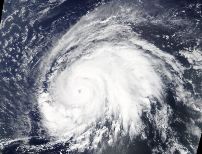 Visible satellite imagery of Hurricane Lorenzo over the eastern North Atlantic Ocean on September 26, 2019, from the MODIS instrument aboard NASA’s Terra satellite. Credit: NASA Worldview, Earth Observing System Data and Information System.

The National Oceanic and Atmospheric Administration (NOAA) provided critical assistance during the international search and rescue (SAR) and recovery efforts that followed the sinking of the M/V Bourbon Rhode in Hurricane Lorenzo last fall. This intra-agency NOAA effort (see figure below) included Hurricane Hunters from the Aircraft Operations Center (AOC), scientists from the National Environmental Satellite, Data, and Information Service (NESDIS) and the Hurricane Research Division (HRD), and marine forecasters from the Tropical Analysis and Forecast Branch (TAFB) of the National Hurricane Center (NHC).
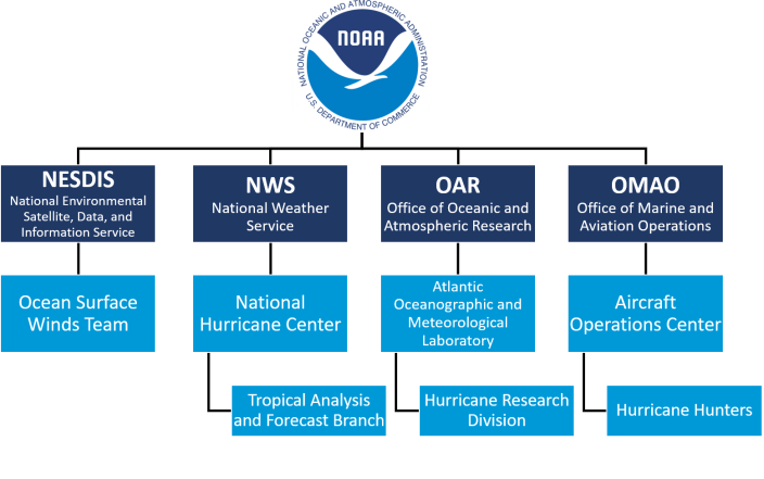 An organizational chart of NOAA offices that provided assistance during SAR and recovery efforts following the sinking of the M/V Bourbon Rhode in Hurricane Lorenzo.

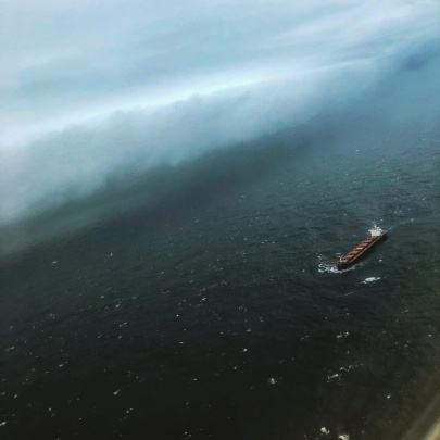
On the morning of Thursday, September 26, 2019, French authorities received a distress signal from the M/V Bourbon Rhode, an offshore tugboat that was en route from Las Palmas, Canary Islands, to Georgetown, Guyana, with 14 crew members on board. The Bourbon Rhode had made a dangerously close approach to the eye of rapidly intensifying Hurricane Lorenzo in the central Atlantic Ocean, and water was entering through the rear of the vessel. At 0600 UTC (2 AM Atlantic Standard Time [AST]) September 26, Lorenzo was a Category 2 hurricane with 95-kt (110-mph) winds and seas 12 feet or greater that extended 240 to 330 nautical miles (275 to 380 statute miles) outward from its center. A 1200 UTC (8 AM AST) TAFB sea state analysis, issued around the same time as the last automatic identification system (AIS) signal from the Bourbon Rhode, showed peak significant wave heights in Lorenzo up to 41 feet. By 1800 UTC (2 PM AST), Lorenzo had strengthened to a Category 4 hurricane with maximum sustained winds of 115 kt (130 mph). The Bourbon Rhode ultimately sank on September 26 in the central Atlantic Ocean.
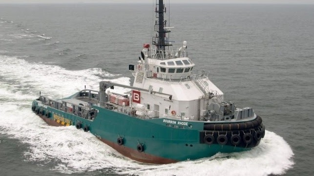 File photo of M/V Bourbon Rhode. Credit: Bourbon Offshore

Since Hurricane Lorenzo was a major hurricane that posed no imminent threat to land, both of NOAA’s P-3 aircraft were preparing to fly dedicated research missions into the storm. As NOAA43 (nicknamed Miss Piggy) transited from Lakeland, Florida, to Barbados on September 26, the French Government and the United States Coast Guard (USCG) reached out and requested SAR assistance. Meanwhile, the nearest marine vessel to the incident site — a bulk carrier named SSI EXCELLENT – was redirected toward the last-known position of the Bourbon Rhode. Later on September 26, NHC/TAFB was contacted by the USCG Rescue Coordination Center (RCC) Miami to begin providing spot forecasts for surface wind and wave conditions that would impact vessels aiding in the SAR efforts. The first TAFB point forecast for the rescue detailed the dangerous marine conditions that were still ongoing in the wake of Lorenzo, with gusty tropical-storm-force winds and combined seas of 20 feet near the incident site.
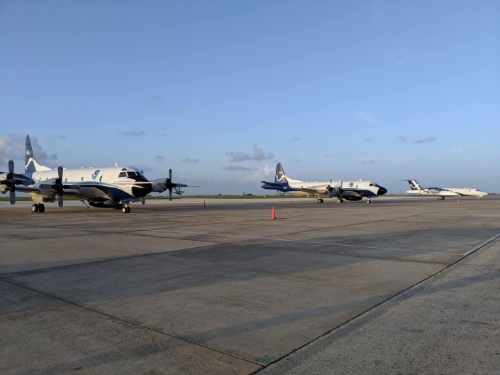 NOAA aircraft fleet in Barbados for Hurricane Lorenzo research missions. The NOAA P-3 aircraft provided critical SAR support for the Bourbon Rhode incident. Credit: LCDR Sam Urato, NOAA Corps


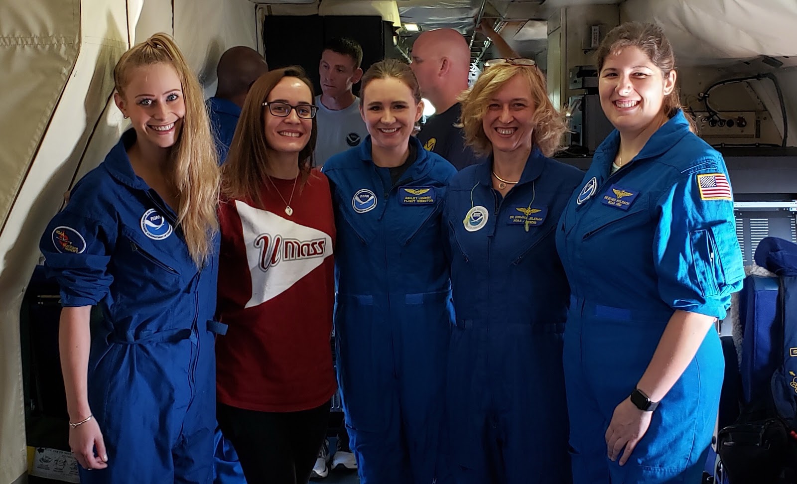
NOAA43 departed Barbados on September 27 with a crew (see list at the end of the post) of AOC personnel as well as HRD and NESDIS researchers. As requested, they planned to fly over the locations of the last Bourbon Rhode distress signals and report any findings. If nothing was sighted, the crew would continue on with the planned research mission into Lorenzo. NOAA43 was the first SAR-capable asset to reach the incident site, but the crew did not find anything upon arrival. With growing concern about the fate of Bourbon Rhode crew members, the NOAA43 crew quickly decided to abandon the Lorenzo research mission and continue SAR support. With little information besides the last-known location of the Bourbon Rhode, they quickly adapted to the situation and developed a SAR flight plan. Crew members rearranged themselves by any available window and called out locations of suspected targets or debris while surveying in the vicinity of the last known Bourbon Rhode position. Poor visibility, extremely large waves, and turbulence from strong rainbands posed difficult challenges as NOAA43 received sporadic emergency beacon signals. With only minutes left before the plane needed to head back to Barbados due to fuel limitations, crew members spotted debris and what appeared to be a life raft. This information was relayed to SSI EXCELLENT, which was en route to the SAR area.
 Convective cell in an outer rainband of Hurricane Lorenzo, taken during a NOAA43 SAR mission on September 27, 2019. The bulk carrier SSI EXCELLENT is also pictured. Credit: Kelly Ryan, NOAA/AOML/HRD


On September 28, NOAA42 (nicknamed Kermit) flew a SAR mission in coordination with SSI EXCELLENT and other supporting marine vessels across the search area. As Hurricane Lorenzo moved farther away, improving weather and marine conditions allowed the plane to fly as low as 200 feet above the ocean surface. The NOAA42 crew (see list at the end of the post) conducted visual searches while listening for emergency beacon signals, guided by previous reports from NOAA43 as well as new information from supporting ships. Crew members located a large debris field and the remains of several sailors, and they directed ships to these locations so the victims could be recovered. The dedicated efforts of NOAA personnel significantly narrowed the search region and guided ships toward the area where a life raft was discovered later that day. Three Bourbon Rhode survivors were rescued from that life raft in the Atlantic Ocean.
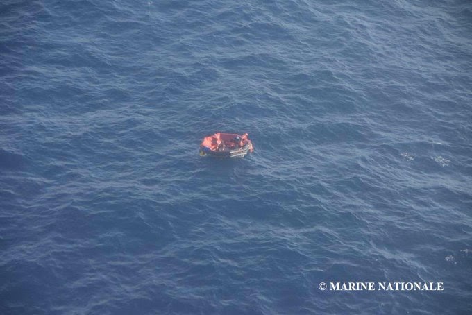 Aerial photo of the life raft carrying three surviving Bourbon Rhode crew members on September 28, 2019. Credit: Marine Nationale (French Navy) via Facebook

NOAA assets played a pivotal role in early SAR efforts, which were led by the Maritime RCC Fort-de-France on the island of Martinique. As the international search efforts continued, TAFB provided six-hourly forecast updates on wind, wave, and weather conditions. From September 26 to October 5, 2019, TAFB produced 35 spot forecasts (see example below) that were shared with RCC Miami and MRCC Fort-de-France in support of this unprecedented SAR operation. Over two weeks, 21 ships and four aircraft searched over 110,000 km2 (about 42,500 mi2) of the central Atlantic Ocean for survivors. Four bodies were recovered, and seven others were declared lost at sea after SAR efforts were officially called off on October 5, 2019.
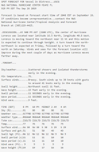 The first of 35 spot forecasts that NHC/TAFB marine forecasters sent to USCG and international partners in support of Bourbon Rhode SAR efforts.

The Bourbon Rhode incident is just one example of how TAFB has evolved to provide impact-based decision support services (IDSS) to the USCG, its primary core governmental partner. Last year, TAFB forecasters produced 56 spot forecasts for 13 marine incidents including SAR missions, distressed vessels, and even a medical rescue. In July 2019, the USCG and U.S. Air Force coordinated a rescue operation of two critically injured people off a disabled fishing vessel in the eastern North Pacific Ocean. TAFB provided spot forecast support for the rescue operation and subsequent transport of the injured people to a Mexican naval medical clinic on Socorro Island. “This information is truly impacting operations,” said Douglas Samp, Search Mission Coordinator for RCC Alameda (USCG District 11).
Additionally, TAFB forecasters prepare and deliver live briefings to USCG District leadership when tropical cyclones threaten USCG SAR regions and U.S. ports. In 2019, TAFB delivered 42 tropical briefings combined to USCG District 7 and District 8, including 25 briefings for Hurricane Dorian. “I cannot overstate how much your [NHC/TAFB] insight into the storm’s effects is vital to our planning and response efforts,” commented Captain Eric Smith, Chief of the Incident Management Branch for USCG District 7.
Tragedies like the Bourbon Rhode highlight the importance of TAFB standing ready to provide year-round IDSS support to core partners. In this case, the dedicated IDSS provided by TAFB forecasters, combined with the valiant efforts of NOAA AOC crew members and HRD and NESDIS researchers, played a critical role in the international rescue efforts that ultimately saved three lives.
— Brad Reinhart
Crew of NOAA43 September 27th Flight
Cmdr. Pat Didier – Aircraft Commander
Lt. Cmdr John Rossi – Co-pilot
Lt. Cmdr Dean Legidakes – Co-pilot
Lt. Cmdr Peter Freeman – Navigator
Mr. Joshua Sanchez – Flight Engineer
Mr. Chris Lalonde – Flight Engineer
Mr. Paul Flaherty – Flight Director
Mrs. Ashley Lundry – Flight Director
Mr. Dana Naeher – Data Technician
Mr. Joe Greene – AVAPS Technician
Mr. Todd Richards – System Engineer
Mr. Damon San Souci – Avionics Technician
Dr. Zorana Jelenak – Principle Investigator (Scientist)
Jezabel Viraldell Sanchez – NESDIS Scientist
Heather Holback – Lead Project Scientist / Radar Scientist
Kelly Ryan – Dropsonde / Radar Scientist
Crew of NOAA42 September 28th Flight
Cmdr. Nathan Kahn – Aircraft Commander
Lt. Cmdr Adam Abitbol – Co-pilot
Lt. Cmdr Robert Mitchell – Co-pilot
Lt. Cmdr Brian Richards – Navigator
Mr. Paul Darby – Flight Engineer
Mr. Ken Heystek- Flight Engineer
Mr. Mike Holmes – Flight Director
Mr. Mike Mascaro – Data Technician
Mr. Joe Greene – System Engineer
Mr. Nick Underwood – AVAPS Technician
Dr. Jon Zawislak – Lead Project Scientist
Trey Alvey – Radar Scientist
Kathryn Sellwood – Dropsonde Scientist
Joe Sapp – NESDIS scientist
Acknowledgments: Special thanks to Zorana Jelenak, Kelly Ryan, and Joe Sapp for sharing their personal accounts of this experience with the author. Additional thanks to Jonathan Shannon, Shirley Murillo, Jon Zawislak, Nathan Kahn, Patrick Didier, and Erica Rule for their helpful input and feedback.
Additional References:
https://gcaptain.com/bourbon-offshore-tug-in-distress-after-getting-caught-in-hurricane-lorenzo/
https://www.maritime-executive.com/article/bourbon-rhode-confirmed-sunk
https://gcaptain.com/bourbon-rhode-sinks-in-the-atlantic-ocean-three-rescued/
Share this:

National Hurricane Center Decision Support Services for the United States Coast Guard

Semper Paratus (Always Ready): A Shared Mission of Watching Over a Vast Blue Ocean
The National Hurricane Center (NHC) has the responsibility for issuing weather forecasts and warnings for a wide expanse of the Atlantic and eastern North Pacific Oceans. Within NHC, the Hurricane Specialist Unit (HSU) issues forecasts for tropical storms and hurricanes in these regions, issues associated U. S. watches and warnings, and provides guidance for the issuance of watches and warnings for international land areas. NHC’s Tropical Analysis and Forecast Branch (TAFB) makes forecasts of wind speeds and wave heights and issues wind warnings year-round for the eastern North Pacific Ocean north of the equator to 30°N, and for the Atlantic Ocean north of the equator to 31°N and west of 35°W (including the Gulf of Mexico and Caribbean Sea). These wind warnings include tropical storms and hurricanes as well as winter storms, tradewind gales, and severe gap-wind events (for example, the “Tehuantepecers” south of Mexico).
The United States Coast Guard (USCG) has areas of responsibility (AORs) that extend well beyond those of NHC, with potential weather hazards affecting the fleet and their missions over the ocean, inland U.S. waterways, and flood-prone U.S. land areas. Although the USCG is responsible for search and rescue missions that may occur due to weather hazards, they are also vulnerable to severe weather and must also protect their own fleet and crews from these hazards.
One of the USCG’s oldest missions and highest priorities is to render aid to save lives and property in the maritime environment. To meet these goals, the United States’ area of search-and-rescue responsibility is divided into internationally recognized inland and maritime regions. There are five Atlantic USCG Search and Rescue Regions (SRRs) (Boston, Norfolk, Miami, New Orleans, and San Juan) and two Pacific USCG SRRs (Alameda and Honolulu) that overlap with NHC’s hurricane and marine areas of responsibility. The other eastern Pacific regions north of the Alameda SRR do not typically, if ever, experience hurricane activity. The multi-million square mile area of the agencies’ overlap allows NHC to provide weather hazard Decision Support Services (DSS) for the USCG.
Building Partnerships with the Districts
The National Weather Service (NWS) signed a Memorandum of Agreement (MOA) with the USCG to provide them with weather support. Over the past couple of years, staff at NHC have had numerous discussions with several of the USCG districts in order to build stronger partnerships. These discussions, primarily involving how NHC can better serve the USCG, established criteria for requiring TAFB to provide weather briefings to key decision makers within the USCG. When criteria are met, TAFB provides the relevant USCG District with once- or twice-a-day briefing packages detailing the weather impacts on their area of responsibility. This information provides the USCG districts with the details necessary to make efficient and effective decisions about potential mobilization of their fleet.

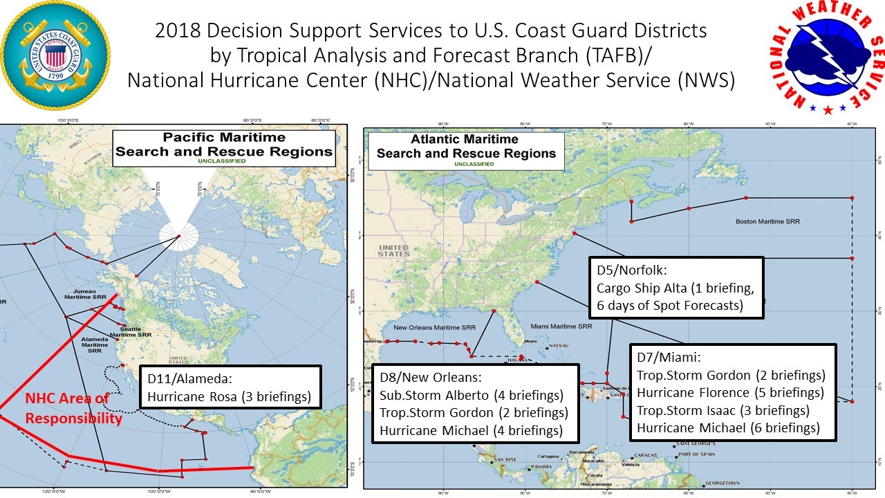
2018 Hurricane Season Briefing Support
During the 2018 hurricane season, TAFB provided 30 briefings to USCG Districts 5 (Norfolk), 7 (Miami), 8 (New Orleans), and 11 (Alameda) for the several tropical storms and hurricanes that affected them. These interactions helped to build the relationships between NHC and the USCG districts and aided the districts in making decisions regarding fleet mobilization, conducting search and rescue missions, and preparation for USCG’s land-based assets and personnel. Some of these briefings occurred during rapidly evolving high impact scenarios, including Hurricane Michael. Michael was forecast to become a hurricane within 72 hours of developing into a tropical depression and was forecast to make landfall within 96 hours of its formation. Ultimately, Michael rapidly intensified into a category 5 hurricane only 3½ days after formation, before making landfall on the Florida Panhandle. Hurricane Michael’s track across the east-central Gulf of Mexico straddled the border of USCG Districts 7 (Miami) and 8 (New Orleans), leading to both Districts taking action in advance of the hurricane.
Support for District 5 (Norfolk)
The NWS’s Ocean Prediction Center, the NHC (through TAFB), and the NWS National Operations Center have worked together to provide weekly high-level coordination briefings to USCG District 5 on upcoming hazards focused on the Atlantic Ocean north of 31°N over the following seven days. Each Monday (except Tuesday if Monday is a holiday) by noon Eastern Time, the NWS provides a briefing that covers the mid-Atlantic region from New Jersey through North Carolina. Typically, the briefing covers the area to roughly 65°W, though the exact area covered can vary based on the week’s expected weather hazards. The USCG, in turn, has been sharing the information with mariners, port partners, and industry groups for situational awareness and critical decision-making.
Future Support
NHC’s TAFB is ready to provide decision support services to the USCG Districts for the 2019 hurricane season. Plans are being developed to continue this type of support for many years to come.

